[Note: The below is cross-posted on my long-time, but not very active, blog Clastic Detritus.]
I recently submitted a review paper along with four co-authors on the topic of signal propagation in sedimentary systems across timescales. The idea that landscapes contain within them information about controls such as tectonics and climate has been a part of our science for a very long time. But, recent advances in the measurement/calculation of rates of processes (for example, with cosmogenic radionuclides) as well as theory and modeling related to how such ‘signals’ generate sediment and propagate across the Earth’s surface to be, potentially, encoded into stratigraphy motivated us to write a review. I’ll post more about the paper once it’s gone through the review-and-revise process, but wanted to write a brief post here on the topic.
Let’s start simple. Consider a sedimentary source-to-sink system with erosional uplands (sediment production) connected to depositional lowlands and/or marine basin (sediment accumulation). A tectonic or climatic change can change the rate of sediment production in the uplands that is potentially recorded down-system as a change in deposition. The morphology and length-scales of the system play a huge role in the behavior, which, in turn affects how (or if) that up-system signal is ‘preserved.’
As analogy, consider human-made debris basins. These structures, common in steep and tectonically active mountains such as the west coast of North America, are designed to mitigate debris-flow hazards on communities built on slopes that are prone to mass failure, especially during precipitation events. Debris basins are positioned on failure-prone slopes above concentrated population and/or infrastructure and designed to capture newly liberated sediment as it flows down slope, preventing that sediment from being transferred further down slope where potential damage and/or injury could occur.

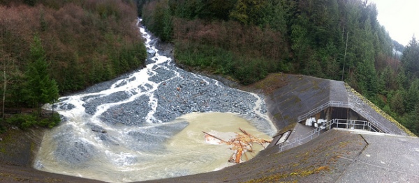
Charles Creek Debris Basin, British Columbia, Canada; photo courtesy of B.C. Ministry of Transportation and Infrastructure’s Flickr page
Essentially, these basins are localized sinks that store sediment, thus preventing the signal (in this case, a rain storm) from propagating down system as a mass-wasting event. However, if the magnitude of the event exceeds the storage capacity of the sink, part of the signal will propagate down system anyway. For example, if the volume of liberated material exceeds the volume the debris basin can hold, the excess mass would bypass the basin after it fills to capacity. For debris basins to be effective they must be emptied following an event such that the storage capacity is returned to its maximum. So, in addition, time and the accumulation of multiple events plays a critical role in system behavior. For example, the sediment volume released from a single rain storm may only be enough to fill a debris basin to 10% its capacity. But, material from >10 storms of similar magnitude, if not removed, would effectively erase the signal-stopping action of the basin, which would allow future events (signals) to propagate down system.
What is exciting (and quite daunting) is applying these concepts to much larger length-scales and much longer timescales. Over longer and longer time periods the only evidence remaining of these mass-transfer dynamics is the stratigraphic record.
–
See this post from FOP about debris basins. And, if you haven’t already, read John McPhee’s “The Control of Nature,” which has a section about debris flows in the San Gabriel Mtns of southern California.
