Category Archives: blog post

New paper on timing of deep-marine slope system evolution using zircon geochronology

We are pleased to share our newest publication coming out of the Chile Slope Systems project. This paper is led by Univ. of Calgary Ph.D. student Ben Daniels and is now online in the journal GSA Bulletin.

This study reports >6,600 new U-Pb zircon ages from the Upper Cretaceous Tres Pasos Formation in southern Chile. We’ve been investigating the sedimentology and stratigraphic architecture of these exceptional outcrops of slope strata for many years, but haven’t had a robust understanding of the timing until now.

Ben (with the help of others in the group) collected numerous sandstone samples for detrital zircons as well as two volcanic ash deposits. Together, the new geochronologic data constrain the age of distinct “phases” within the Tres Pasos Formation across a ~100 km long by ~2 km thick outcrop belt. With this framework, we discuss rates of progradation/aggradation, comparison to other well-studied slope/margin systems, and potential external controls on the basin-scale architecture. Additionally, we also include a discussion on the use of detrital zircon to calculate maximum depositional ages (MDAs) that will be of interest to anyone using detrital zircon geochronology for sedimentary system analysis.

The figure below (Fig. 2 from the paper) is a regional stratigraphic cross section showing the large-scale architecture, paleocurrent data, and these new U-Pb ages all in one chronostratigraphic framework.  

Huge congrats to Ben on spearheading this effort!

Sedimentology and Scientific Ocean Drilling (Video)

The short (~4 minutes) video below features Pincelli Hull (Yale University) and me discussing the job of a sedimentologist on an IODP (International Ocean Discovery Program) expedition. If you’re interested in learning a bit more about what it would be like to participate in these expeditions, this video is a good introduction.

The video was produced by ScienceMediaNL and includes footage from IODP Expedition 342, which Celli and and I sailed on in 2012.

Virginia Tech sedimentary geoscience trip to Outer Banks, NC

The broader Virginia Tech sedimentary geoscience group (faculty and graduate students of VT Sedimentary Geochemistry and VT Sedimentary Systems and related disciplines) just returned from a six-day field trip visiting locations in the Outer Banks barrier island system of North Carolina. The trip was the culmination of a grad-student seminar this spring semester on coastal sedimentary environments. The students researched topics of interest, identified appropriate locations, designed field activities, and then led that day of the trip. The nine graduate student participants collaborated to design, write, and produce a field guidebook as well.

Topics of interest included: sediment transport dynamics, facies distribution and stratigraphy, biology/ecology of coastal environments, and anthropogenic effects/activities (e.g., beach nourishment). Field activities included: grain-size analysis (using sieves), beach profiling, trenching, push coring, and lots of primary observation.

Most of us in this group study sedimentary rocks so just getting to watch sediment transport happen before our eyes and make the connection to deposits that (might) get preserved into the rock record was an overarching objective.

In addition to the field locales, we had great visits to the UNC Coastal Studies Institute and the Army Corps of Engineers Field Research Facility. Huge thanks to our hosts, these visits added a lot to our trip.

The photos below summarize just some of the trip.

Day1

Day 1: unnourished beach at Duck; “outcrop” of eolian cross-stratification; beach profiling at Nags Head; eolian ripples/dunes at Jockey’s Ridge State Park

Day 2: Coring the foreshore; Examining coarse layers in foreshore; Coring the back-barrier; Well-developed microbial mat in estuarine deposits

Day 2: Coring the foreshore; Examining coarse layers in foreshore; Coring the back-barrier; Well-developed microbial mat in estuarine deposits

Day 2: Watching sand move on the south side of Oregon Inlet

Day 2: Watching sand move on the south side of Oregon Inlet

Day3

Day 3: Discussing beach-to-overwash-fan transition; Exploring overwash fan; Push coring estuarine sediments; View of barrier island facies tracts from Cape Hatteras lighthouse

Day4

Day 4: Exploring the wetlands and swamps of the coastal plain at Alligator River National Wildlife Refuge.

Day5

Day 5: Exploring Currituck Sound (large estuary behind barrier island) by pontoon boat; Taking salinity and pH measurements; Examining estuarine mud via push cores.

Day6

Day 6: Visit to the Army Corps of Engineers Field Research Facility; Back to Jockey’s Ridge State Park to to examine grain-size trends in eolian landforms.

Here’s the group (minus one grad student) on the final afternoon at Jockey’s Ridge State Park.

group


Review paper on signal propagation in sedimentary systems by Romans et al.

I’m pleased to announce the publication* of a comprehensive review paper of signal propagation concepts in sedimentary system analysis in the journal Earth-Science Reviews. My co-authors and I initiated the idea for this review way back in the spring of 2013. The notion that tectonic and climatic changes can be recorded in erosional landscapes and the depositional record as ‘signals’ for geologists to extract and examine has been around for decades, if not centuries. However, more recent ideas concerned with how such signals move through the landscape — and with that movement, how the signal of interest may lag, be dampened/amplified, or even destroyed — deserved a synthesis in our opinion.

The illustration below is the first figure of the paper and an attempt to summarize the idea of signals and signal propagation conceptually and schematically. We focus on sediment supply as the main ‘carrier’ of signals from source to sink.

We don’t set out to solve all the problems and answer all the questions related to signal propagation in this review. Rather, our aim is to present the ‘state of the art’ and identify the most interesting questions to a broader Earth science readership with the hope that researchers in overlapping fields (e.g., geomorphology, climatology, oceanography, tectonics, ecology, biogeochemistry, and many more) find some value in our perspective.

You can find a link to the paper on the Publications page.

* this is the online early (‘in press’) version of the paper, which has a DOI and can now be cited

Debris basins and signals in sedimentary landscapes

[Note: The below is cross-posted on my long-time, but not very active, blog Clastic Detritus.]

I recently submitted a review paper along with four co-authors on the topic of signal propagation in sedimentary systems across timescales. The idea that landscapes contain within them information about controls such as tectonics and climate has been a part of our science for a very long time. But, recent advances in the measurement/calculation of rates of processes (for example, with cosmogenic radionuclides) as well as theory and modeling related to how such ‘signals’ generate sediment and propagate across the Earth’s surface to be, potentially, encoded into stratigraphy motivated us to write a review. I’ll post more about the paper once it’s gone through the review-and-revise process, but wanted to write a brief post here on the topic.

Let’s start simple. Consider a sedimentary source-to-sink system with erosional uplands (sediment production) connected to depositional lowlands and/or marine basin (sediment accumulation). A tectonic or climatic change can change the rate of sediment production in the uplands that is potentially recorded down-system as a change in deposition. The morphology and length-scales of the system play a huge role in the behavior, which, in turn affects how (or if) that up-system signal is ‘preserved.’

As analogy, consider human-made debris basins. These structures, common in steep and tectonically active mountains such as the west coast of North America, are designed to mitigate debris-flow hazards on communities built on slopes that are prone to mass failure, especially during precipitation events. Debris basins are positioned on failure-prone slopes above concentrated population and/or infrastructure and designed to capture newly liberated sediment as it flows down slope, preventing that sediment from being transferred further down slope where potential damage and/or injury could occur.

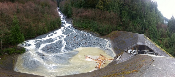
Charles Creek Debris Basin, British Columbia, Canada; photo courtesy of B.C. Ministry of Transportation and Infrastructure’s Flickr page

Essentially, these basins are localized sinks that store sediment, thus preventing the signal (in this case, a rain storm) from propagating down system as a mass-wasting event. However, if the magnitude of the event exceeds the storage capacity of the sink, part of the signal will propagate down system anyway. For example, if the volume of liberated material exceeds the volume the debris basin can hold, the excess mass would bypass the basin after it fills to capacity. For debris basins to be effective they must be emptied following an event such that the storage capacity is returned to its maximum. So, in addition, time and the accumulation of multiple events plays a critical role in system behavior. For example, the sediment volume released from a single rain storm may only be enough to fill a debris basin to 10% its capacity. But, material from >10 storms of similar magnitude, if not removed, would effectively erase the signal-stopping action of the basin, which would allow future events (signals) to propagate down system.

What is exciting (and quite daunting) is applying these concepts to much larger length-scales and much longer timescales. Over longer and longer time periods the only evidence remaining of these mass-transfer dynamics is the stratigraphic record.

See this post from FOP about debris basins. And, if you haven’t already, read John McPhee’s “The Control of Nature,” which has a section about debris flows in the San Gabriel Mtns of southern California.